


FlyerTon
-
Posts
2,810 -
Joined
Content Type
Profiles
Forums
Events
Store
Posts posted by FlyerTon
-
-
Hold on to your hats at the end of the week, gonna be blowy.
Its actually a better forecast for 9am Friday than it was yesterday, gusts of 94mph have lessened, but still...
Saturday looking interesting, whipped in westerly gusts 60mph +
Mallaig forecast gusts of 74mph on Saturday. Surprisingly, no Met Office weather warning out yet.
Maybe they are waiting to closer the time?
0 -
Apparently pished guy on a Space hopper stopped in Dundee:
http://www.mirror.co.uk/news/uk-news/cops-stop-drunk-new-years-4923988
"The unnamed man was spotted by officers as he attempted to bounce his way through the Marketgait underpass in Dundee at around 3am on New Year’s Day"
0 -
After a freezing foggy day on Monday (west central), Hogmanay looks like being mild wet and windy.
0 -
Fair bit of snow dan south today (radar link below)
Edit to add they are saying the snow is not heading for Scotland today, but looking at that radar track it appears to be moving north east towards us.
0 -
-
A77 closed between Ballantrae and Cairnryan due to a landslide at Glenapp.108 mile diversion.0
-
How many weans who have Scottish places named after them?
I can think of:
Iona
Isla (y)
Lewis
Morven
Skye
(Not that I think these are stupid, by the way. How many more can you think of?)
0 -
-
-
26 years ago today.
The flight path of PA103 had it flying over Scotland's biggest city just about 7 minutes or so after Lockerbie.
From: http://lockerbiedivide.blogspot.co.uk/2010/12/but-flight-103-was-behind-schedule.html
To establish the flight Path across the UK, I return to the conversation with ATC Brown:Q And then A20 route?A It was a low level airway from London Heathrow going through a reporting point calledTrent, which is TNT.Q And then, "upper alfa 2 Pole Hill UB for [156] Margo direct Glasgow."A That's the route that the aircraft would continue to take. After Trent, it would proceed via Upper Humber 2, via Pole Hill, upper Bravo 4 to Margo, flight direct from Margo to Glasgow, and then follows the upper air route 590 to 59 north and 10 west.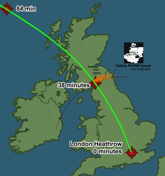
R.I.P.
0 -
From:
http://www.mirror.co.uk/news/uk-news/uk-weather-polar-vortex-bring-4810075
"A polar vortex is expected to bring Siberian weather to Britain over Christmas, causing travel chaos for millions.Forecasters predict storms, snow, ice and temperatures as low as -12C.The Met Office said a weakening of the polar vortex – the North Pole’s dominant low pressure system – will block mild weather from the West and allow a cold front to arrive from the East"0 -
-
-
144 mph gust recorded today on St Kilda:
0 -
Caringorm mountain summit weather station status showing 'possible fault'
With a 100mph gust recorded there today, as per the radio, that's not surprising.
0 -
Yellow warning of high winds out early for next Wednesday, 10th Dec.Currently yellow, but expect this to be upgraded to amber if the 70mph gusts are expected nearer the time.
High wind warning now upgraded to an amber in some areas.
"Very large swell generated over the Atlantic to the south of the very deep depression will lead to exceptionally large waves affecting west coasts"
Warning also out for snow on Friday:
0 -
-
-
This is a useful site I've come across (tis' for surfers),http://magicseaweed.com/news/black-wednesday-swell-for-north-atlantic/7017/nice animation of the storm as it moves towards us. I've heard concerns about high tides and the possibility that a storm surge could cause problems.
This chart looks worrying (below) with that storm's pressure dropping as much as 950mb in the center with those tightly packed millibars to the south, that's going to be a beast if it happens and the west coast is going to get the worst of it.

The isobars on the Met Office forecast pressure chart for Wednesday on the link look tightly squeezed. 940mb low.
Current forecast winds showing sustained westerly at 41mph, whipped in gusts 71mph, later veering NW.
0 -
Yellow warning of high winds out early for next Wednesday, 10th Dec.Currently yellow, but expect this to be upgraded to amber if the 70mph gusts are expected nearer the time.
Risk of storm force winds, western Scotland on Wednesday.NB: Out of a scale of 1-12, storm force is a 10:
0 -
This system that people were getting hysterical about last week has stuck between Greenland and Iceland, all its done so far is send a warm front towards us as it weakened in the Atlantic a couple of days ago and as it reaches us its pushing the cold air from the Arctic away from us at least briefly. http://www.yr.no/satellitt/europa_animasjon.html
Still keeping an eye on that system since it could affect us during the week.
Met Office forecasting gusts of 66mph on Wednesday, central west coast.
ETA: Update now showing 69mph.
0 -
Quite cold today.
A bit icy on Friday morning:
http://www.metoffice.gov.uk/public/weather/warnings/#?tab=warnings®ionName=st&fcTime=1417737600
0 -
Could this be the starter for the commencement of the worst winter in 31 years (so they say....)
0 -
Scrubbed
0


The Storms & Severe Weather Thread
in The General Nonsense Forum
Posted
They have now issued a yellow for Friday.